Popup

Thursday, 2 December 2021

The incredible Sumerians Part 2 : A. The First Cities, the Great Flood and much more


Home Page home page 

The Incredible Sumerians, part 2 

The Uruk Period, the first cities, and the Great Flood

The second period of Sumerian history is called the Uruk Period  (4100–2900 BC) and is marked by the emergence of the world’s first cities.

Part A

Characteristics of a ‘City’ and ‘Civilisation’

The term ‘civilisation’ simply comes from the Roman word for city, but even in Roman times 'being ‘civil’ acquired a value judgment (of being a good Roman citizen). 
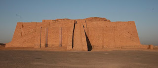
Restored Ziggurat of Ur

In sixteenth century France (in a world on the edge of the 'Age of Enlightenment') ‘being civilised’ acquired other value judgments : indicating sophistication, good manners, rationality, enlightenment and ‘superior’ behaviour (as contrasted with a more ‘primitive' society).

This can cause some confusion, but remember, for the noun (especially in Archaeology, anthropology and related disciplines) pare back the value judgments: it simply refers to a culture that has built cities.

It may not sound dramatic as the more nuanced adverb, but cities and urbanisation are a quantum leap forward in social organisation.

But what defines a city (in the ancient world) rather than a large agricultural community?

Childe, in the 1936 book (and later) defined a list of characteristics which included size and population density, sophistication, specialised workforce, taxation, monumental building, ruling class, symbolic representation, science, sophistication and organisation beyond kinship.

Characteristics of Urbanisation

To simplify somewhat: a city (urbanisation) is characterised by a large specialised central settlement inside of which much of populace is not directly involved in producing food.

It requires and is characterised by several things: 

1. A significant, available, food surplus.

Each city has to be closely connected to agricultural towns, farms, fishing villages and herding camps that supply food and other resources to the city, in exchange for finished goods and services. 

Sumer, at its height, was the most agriculturally productive region in the world, serviced by complex irrigation and transport canals and it supported previously unheard of population density.

2. Stratified society.

In the city there is a full-time bureaucracy, military, a stratified society and complex industry. The specialisation allows economies of scale and more rapid advances in knowledge.

3. Transport

Transport aids the free flow of goods and services. Sumer was well serviced by canal transport. Uruk had such an extensive network of canals it has been called the ‘Venice in the desert’.

Since the Ubaid times Sumerians had oxen carts. The donkey was a very welcome addition, arriving in the middle of the Uruk period.

 4. Currency and sophisticated trade.

Sophisticated trade cannot occur without some form of currency

From Palaeolithic times humankind used commodities as the first currencies.

This is sometimes confused with barter but here, individuals (who are not traders) accept a well recognised commodity which has an understood value as a means of exchange. And they are prepared to do so in quantities beyond what they need for personal consumption.

Cattle or other livestock was currency for expensive items such as a (noblewoman’s) bride price, or to build a defensive tower across a range of cultures. 

Flint, obsidian, metal, beads, shell -jewelry, axe heads, salt and rum have all been used at various times throughout human history.

Metal had to be imported into Sumer and didn’t come into its own until a later period. The predominant commodity used during the Uruk era for large purchases was grain.

Other commodities were used for smaller purchases. (In a later period, there is even the record of payment to a labourer in beer.)

5. Records and accounting

How can grain be used as a currency? Did the Sumerians carry bushels of grain around to pay labourers? 

If not, how did they make payments? The answer (at least for significant purchases) was the token system.

Tokens arose during the very beginning of the Neolithic period, paralleling the cultivation of grain and communal storage. If a landowner was to deposit his surplus of grain in a community warehouse, he would definitely want some record of what was his! 

The first examples of this in Northern Mesopotamia date back to 9,000 BC in the earliest Neolithic times.

Stamp seals (carved in stone to be pressed into wet clay) were invented soon after, as a type of official signature. This technology was brought to Sumer with the first Neolithic farmers and irrigators. 

During the Uruk period (5 millennia later) tokens and seals continued to evolve into a complex accounting system. 

There was never any need to lug bulk grain or other commodities around. Any large transfer of ownership was achieved by the token system, a bit like transfers recorded within a bank, but in this case it was administered through the community storehouse under the control of the priestly class.

The centre of the community at that time was the temple. The leader of each city-state and its surrounding lands and towns was a king/priest. 

Priests and their acolytes were not only responsible for religion and holy ceremonies they were in charge of  higher learning, taxation, records, administration and running the communal granary.

The increasing use of symbols

Over time, different tokens were used until they covered something like sixteen important commodities. 

(Counting) tokens to aid calculations were then introduced . A small cone denoted 1, a ball was 10, and a large clay cone was 60.

Special round clay containers (bulla) were designed (like a lock box at a bank) to preserve a collection of tokens held inside. They could only be opened once (to prevent tampering). 

As these containers had a record of the contents and personal seals on the outside, it led to simple clay tablets being used, instead, for simpler records.
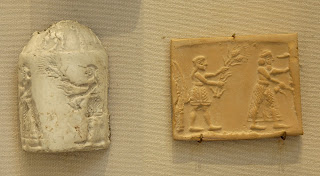
To improve security and to show the status of prominent dignitaries, , cylindrical seals were invented in place of simpler stamp seals. These were definitely a work of art. They were only an inch high but elaborately carved so they could be rolled onto wet clay to form an especially impressive signature.

Soon after, the Sumerians invented symbolic representation of numbers (with the main base 60) to further  assist with accounting and their solar calendar.

The whole system was becoming too cumbersome as society and trade became more complex.  

Pictograms, the world’s very first form of writing

The need for Sumerians to represent more complex concepts led to the world's first true form of writing (pictorial writing) around 3500 B.C .

Pictographs (picture words, and petroglyphs) in simpler forms date to Paleolithic times.
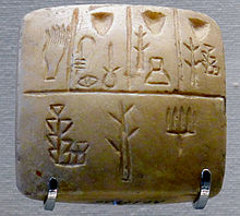
This first form of Sumerian writing seemed to grow out of the token system and was logographic (each symbol represented a word (or morpheme).

Sometimes a ‘determinative’ was added (a symbol which specified semantic class) which meant the same symbol could be used for a range of items or concepts.

Drawing curves on clay is difficult, and the Sumerians soon began experimented with a range of writing systems (often concurrently and often combined).

As Sumerian writing predated Egyptian writing and the Egyptians did not show this phase of experimentation, it is generally accepted that it was the Sumerian writing that inspired Egyptian hieroglyphics.

Cuneiform, one of the world’s Great writing systems

‘Cuneiform’ writing emerged around 3400 BC.  

Its name means ‘wedge shaped’ and it involved a wedge shaped stylus, elimination of curves and the use of highly stylised symbols. The writing also became from left to right (not top to bottom as before).

Cuneiform writing became amongst the greatest writing systems in antiquity. It lasted through to 100 AD. with many adaptations. It was eventually used for writing fifteen languages.

Why was cuneiform so successful, apart from its specific adaptation to clay tablets? 

It became phonetic, or at least partly so.

Sumerian was mostly monosyllabic. If you ignore the accents, a lot of words are spelt the same way (they are homonyms). So the Sumerian šu (“hand”) could stand in for a lot of similar sounding words.

Also (in keeping with pictographs) a symbol could stand in for a series of related but different-sounding words “sun,” “day,” “bright” further reducing the number of symbols needed.

Semantic ‘determinatives’ continued to be used to keep the number of symbols within reasonable bounds, and pictographs continued to be used for names.
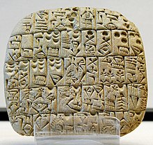
Contract for the sale of a field and a house
But the great problem for cuneiform writing is its complexity. There was eventually 700 different symbols and their shape and meaning could vary over time and place. 

It was finally displaced by alphabets (or at least the consonant-only 'alphabets', like Phoenician writing, that we call ‘abjads’ ).

These ‘alphabets’ were first invented by a group of Semitic workers and traders  living in Egyptian- occupied lands of the Sinai and south Canaan   around 2,000 BC. 

Vowels were later added to reduce ambiguities.

Alphabets were originally designed for writing on papyrus and parchment (with ink). 

When they are carved (e.g. wood or stone) with ancient technology, the characters have to have a more angular shape (which incidentally is one of the reasons runes were developed around 150 AD by the Norse and Germanic people) .

Papyrus was easier to use than clay tablets but, perhaps almost as importantly, alphabets were so much simpler to learn and use.

There were attempts to simplify cuneiform writing. The best was by the clever Persians during the Achaemenid Empire (550 BC–330 BC). They used a cuneiform alphabet with 36 phonetic characters (including vowels) and 8 logograms. 

But by this time the use of cuneiform writing was passing and the Old Persian characters were eventually abandoned.

Even though writing emerged in the late Uruk period, we have scant written records from this time. 

The whole period is sometimes called the ‘proto-literary’ period because it was characterised more by the increasing use of symbols that led to the emergence of writing.

Tokens would become almost obsolete. Contracts, vouchers, payrolls, accounts and private ownership was all recorded on clay tablets. 

Some of these were intended as temporary records, but there are something like tens of thousands of Sumerian and other tablets in the back rooms of museums around the world, some not yet not fully translated. It is only a fraction compared to what has been lost.

First urbanisation

Most will accept that world's first urbanisation was achieved early in the Uruk period (4100–2900 BC). 

For reasons already explained, archaeology is difficult in Sumer. Wood and stone were in short supply and most construction was mudbrick. There was a tendency to recycle and build on top of older layers. The oldest ruins ended up deep under layers of silt and overlain by more recent, but still important, archaeological remains.

In what became one of the most important city in much later times, Babylon, archeology is further hampered by its high water table.

But wasn’t there cities in the Neolithic period?

No. Some people have been tempted to claim certain Neolithic settlements as the world’s first cities. One example is Çatalhöyük in Turkey, but it never achieved urbanisation.
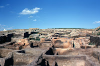
Çatalhöyük

Jericho.

Jericho has also been suggested as the world’s first city or 'the world's oldest continually occupied settlement'. Unfortunately it is neither.

It was an impressive settlement, dating back to the dawn of the Neolithic period but did not reach urbanisation until the early Bronze Age (maybe by 2600 BC.) when the Eastern Mediterranean coast and surrounding lands were coming into their own with the rise in trade with Egypt.

Jericho has several periods when it was abandoned, and so it fails the test for the world’s longest continuously occupied settlement as well.

For instance, it was completely destroyed maybe in the 17th or 16th centuries BC. (Likely by the Egyptians). 

Ahmose I defeated the Canaanite ‘Hyksos’ (foreign rulers of northern Egypt) around 1550 BC. and then campaigned as far as Byblos in Lebanon. 

A reasonable assumption is that he expelled many Canaanites from Egypt (or they fled before his armies), perhaps inspiring the Biblical story of the Exodus.

A small unwalled settlement was rebuilt there in the 15th century BC but it was soon abandoned and Jericho is said to have been empty till the 10th/9th centuries BC. despite historically inaccurate claims that the Israelites under Joshua sacked it (probably in the mid-late 13th century BC).

Was Eridu the world’s first city, then?

In Sumerian tradition the old port city of  Eridu was Sumer’s (and hence the world’s) first city.
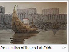
It was certainly one of the oldest Sumerian settlement of any substance, being established by famer-settlers in 5,400 BC and was a major settlement in the Ubaid period.

It was very well favoured, being well suited for irrigation, near the sea for food and trading, handy to marshes (for fish, birds and other resources) and close to herding activity. 

Unfortunately for Eridu, the sea later marched (a considerable distance) south under the influence of silting and falling sea levels (in the first thousand years), all made worse by the shallow fall of the land. 

The low basin where it was situated was especially prone to flooding and Eridu's fortunes fluctuated considerably. It was abandoned at times, but estimates of when this was vary enormously.

One gain from its growing distance to the sea was a massive expansion of the nearby marshes which (during the flood season) formed a giant lake the size of Galilea.
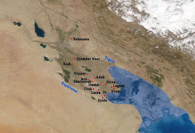
Sumer , with new coast line (Wiki)

Max Mallowan described Eridu as an 'unusually large city' of  ‘not less than 4000 souls’ covering 8-10 ha (20-25 acres) during the Ubaid period. Kate  Fielden alternatively suggested it reached this size  ‘by 2900 BC’.

These estimates are over a thousand years apart ,showing just how murky our knowledge of this period is and how different estimates often contradict each other.

A more important question is, how a settlement of considerably less than 10,000 be called a ‘city’?

 It was not likely.

Uruk, the favourite contender

In Sumerian legends Inanna, the young (but mischievous) patron Goddess of Uruk, challenged her father, Enki, to a drinking competition. While he was drunk, she tricked him into giving her the important  Mes’ (the essence of civilisation) which she took from Eridu to Uruk.

The Mes’s form and characteristics were not specified, though it had some sort of physical form because she was able to put it on display. It was also sometimes called a (minor) God in its own right. 

It included the knowledge, institutions, technology, laws and culture (anything that the Sumerians thought made civilisation possible).

It seems the Sumerians believed the main civilising force had passed from Eridu, the important settlement of Ubaid times, to Uruk, the star of the Uruk period.

Uruk was long the most impressive of all Sumerian cities, establishing cultural hegemony over a vast region.
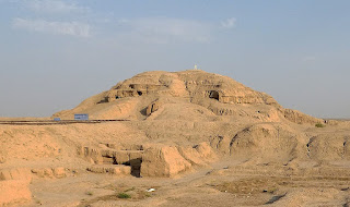
White temple and Ziggurat (wiki)

It began around 5,000 BC. and soon absorbed a neighbouring town, resulting in not one but two temple districts. 

From 4000 BC the settlement had a massive ziggurat dedicated to Anu, the sky God. This went through 14 phases of construction.

This included, in the late Uruk period the erection of a great white temple on top,  plastered with gypsum. This was 20 metres above the city and would have been able to be seen from a great distance. .

The second temple district,  Eanna (500 metres away) had more modern  temples and monumental buildings. Between the two were busy workshops and residential districts.

Throughout the whole period, which bears its name, Uruk grew rapidly. Unfortunately, the time periods are extremely imprecise with competing estimates but it seems to have reached urbanisation sometime in the early Uruk period. 

By 3700 BC it was said to have reached between 175–250 ac (70–100 ha). 

It was later than this, but still during this period, the culture of Uruk (and urbanisation) began to spread to other sites.
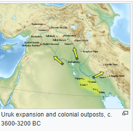
Uruk eventually managed to expand its sphere of influence as far as Upper Mesopotamia, northern Syria, western Iran and south-eastern Anatolia. 

The actual mechanism of this ‘Uruk Expansion’ is not fully understood but it seemed to be a combination of military expansion and cultural and trading dominance.  

The greater region and its surrounds was not exactly the one culture, there were regional difference and differences in language in places like Elam and Northern Mesopotamia.

By the end of the period, Uruk had reached 40-50,000 citizens with 80,000-90,000 in its surrounds.

Tell Brak, a little known contender (as the world's first city)

A team of American and British archaeologists surveying Tel Brak in Syria, believe they have found the world’s first city, and it was in Syria (Upper Mesopotamia) instead of Sumer.

They published (in 2011) the culmination of over thirty years work and publications.

The original name of the city is  unknown but it was later called Nagar. It was founded during the earlier northern Halaf culture. Situated on a river crossing between Anatolia, the Levant and Sothern Mesopotamia it became an important trading and manufacturing hub absorbing the earlier ‘northern Ubaid’ culture.

During the Ubaid and Uruk period, its growth mirrored that of Sumer and it became the largest city of  Northern Mesopotamian at that time.

At the start of the Uruk period Tell Brak was already 55 hectares. 

It was bigger than Nineveh, back then known as Ninua, not far from Mosul in northern Iraq. 

Nineveh was destined to become the world's largest city around 700 BC but back then it came in  second to Tell Brak at 'only' 40 hectares. 

By the end of the Uruk period 'Brak' had reached 130 hectares, making it a serious contender with Uruk as the world’s first city.
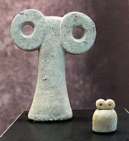
It had a sophisticated temple which was wood panelled inside and a semi-colonnaded façade, the first of its kind. It is called the ‘eye’ temple for the particular alabaster and bone votive figures found inside thought to be representing the local all- seeing Goddess. It had strong walls and the presence of four mass graves suggest periods of warfare.

In the late Uruk period Tel Brak had an Uruk enclave and considerable Uruk influence. 

Interesting this enclave was abandoned and levelled at the end of the Uruk period and the city suffered a significant contraction.

A similar but smaller city, Hamoukar, to the east was also destroyed around 3500 BC after a siege. 

The culprits are unknown but most suspect a military expedition from Uruk.  Civilisation had obviously brought the wonderful benefits of siege-warfare, looting and slavery.

And the winner is?

It was in the early Uruk period that the world’s cities had begun to emerge.

Sadly, due to the problems of excavation in Sumer, it is impossible to decide if the first city was Uruk or Tell Brak. 

It might be tempting to favour Uruk which continued to be the greatest city in Sumer for Millenia.

Whatever the answer, Sumer owed a great debt to the north that we have sometimes underestimated. 

It was where many of the innovations began that allowed the settlement of Sumer.


 Part B

The Sudden Collapse

Around 3100 BC. just when Uruk was at the height of its power, it and the cities of Southern Sumer faced some sort of sudden catastrophe.

Uruk’s influence collapsed, long distance trade in and out of Sumer dwindled to a trickle

The Uruk culture ceased, only to be replaced by the inward looking  Jemdet Nasr Culture (3100 to 2900 BC ). 

The Jemdet Nasr Culture had already been in the back water regions of Northern Sumer but now it extended its influence over the southern cities, even Uruk. 

Settlements became less dense and hand painted pottery emerged, suggesting the end of cheaper mass production that was possible in Uruk times.

Exactly what happened politically during this period is unclear but at the start of the next period (the early dynastic period 2900–2350 BC) hegemony had passed to the (northern) city of Kish which for a time controlled Uruk.

Kish was Akkadian (Semitic), part of the greatest minority group in Sumer. 

Was it a Semitic invasion from the north? 

No, they were already there

Archaeologists initially believed that the fall of Uruk was due to migration of Semitic people into the northern regions.

Ancient DNA shows they were there likely from as early as Mesolithic times.

It is harder to extract viable DNA from ancient samples in a warm climate, but recent studies show that the ancient (Semitic) natives of the Levant were distinct from the ancient people of Zagros (Iran) and Anatolia (Turkey). They were the three groups that would form the great Neolithic powerhouses.
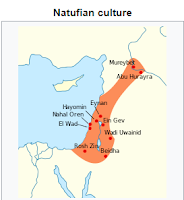
Those in the Levant had connections with people of Arabia and north western Africa but had diverged from them by 13,000 BC or maybe even as early as 22,000 BC . 

The bulk of the DNA for modern day Palestinian, Lebanese, Jordanians and Syrians (speakers of Levantine Arabic) comes from this ancient group. 

There has been the addition of other DNA over time (which is not too surprising in such a busy corridor for people movement).

In other words, the ancestors of the ('Levantine') Semitic and related people arose in the Levant in Late Paleolithic times. They were part of the Mesolithic Natufian culture (beginning 13,000 BC). 

It was they, in turn, who were responsible for the beginning of Neolithic culture (10,000 BC). 
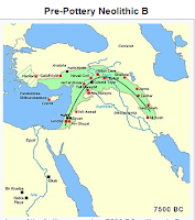

By 7,500 BC Neolithic culture had spread decisively across the whole fertile crescent including into what is now Syria, north of Sumer, giving rise to a number of Neolithic and then Copper Age settlements and cultures. 

As soon as we can tell, the people north of Sumer were speaking Eastern Semitic, which included Akkadian.

To reiterate, they were most likely they were already there in Mesolithic, Natufian, times and if not, they spread out in the earliest Neolithic times. 


Rise of the Semitic Traders 

We will come back to the fall of the Uruk culture in a minute but this is a good time to divert and briefly discuss this group.

Later, the 'Arabs' of the Gulf region were destined to become famous traders. 

Now we can tell that their northern cousins were already in position in the Levant and northern Mesopotamia and had a central role in 'northern' trade from prehistory onwards.

They straddled the northern land route in and out of Egypt, the land routes between Sumer and Anatolia and the overland route to the Zagros region, Afghanistan and India.

Both Egypt and Sumer were great producers of grain, and became very wealthy, but were short of many natural resources like metal and wood. They often used reed boats.

The Semitic people of the Levant (ancestors to the Phoenicians and others) also had the cedar of Lebanon, and other sources of fine wood. 

Also, encouraging sea trade, the eastern part of the Mediterranean was also particularly favourable, due to the combinations of winds, currents, and general topography. 

So the coastal Semitic people became not only land traders, but the great sea traders of the Mediterranean achieving a dominance that would last millennia. 

Sea trade can carry greater loads than land trade.

It was sea trade above anything else that really opened up Egypt to the grain markets of the ancient world and led to its great rise.

The Semitic people of the eastern Mediterranean dominated this sea trade through till the fall of Carthage to the Romans in 146 BC.

Coming back to the 'last days' of the Uruk period, these overlapped with the early Middle East Bronze Age (beginning 3300 BC.) by several centuries. 

Bronze requires not only copper but tin which is relatively rare and the 'Bronze Age' is synonymous with complex, highly organised, trade.


Climate change

Other Invaders? 

We don't have genetic studies closer to the time but modern Syrians show an influx of genes from the Caucasus and Zagros region. Our history tells us this was likely later, occurring  during the time of Amorite Mesopotamia (see later blog) 

No, the northern (Akkadian) part of Sumer recovered first and whatever happened had to be something particularly affecting the south, not the north. 

The Uruk period saw the progressive loss of the ‘Indian’ Monsoon, especially affecting Arabia which continued to dry out. Settlements there withdrew to oases and favourable areas of the coast. 

For the rest of the Middle East, the Uruk period was colder and wetter (under the ‘Piora Oscillation’ 3900-3000 BC.) Now many archaeologists postulate the Uruk culture fell due to  a long dry spell, causing a rise in salination.

Was there something else as well?

Does the Great Flood Myth refer to a real event?

Climate change sometimes brings a period of climate instability, not just drought but interspersed with floods. The modern world has experienced this with our own recent climate change.

The Sumerians firmly believed the Uruk  period ended with the Great Flood.

Of course, the Sumerians were not the only ancient people to have a flood myth,  but it was their version that inspired many of the others including the Dravidians (Indians), the Romans, the Greeks ... and the Flood Myth in the Bible. 
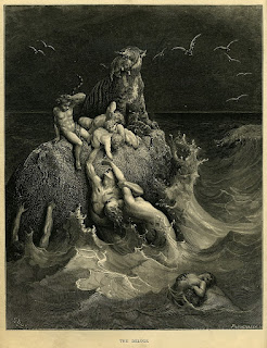
Gustave Dore, Bible Illustration
The early books of the Bible (Genesis, Exodus, Leviticus, book of Numbers and Deuteronomy) are now thought to be first recorded when many Israelites were held captive in Babylon (from around 598 BC). 

 This means that there is a strong Mesopotamian influence on Biblical myths and many were written much later than the purported events they describe.

Sumerians have different versions of their flood 'myth'. 

They all, like the Bible, include the tradition that their antediluvian leaders lived for many centuries. 

The main Sumerian ‘Noah’ was called Ziusudra and was the leading priest/king of all of Sumer.


One later version bears a particularly uncanny resemblance to the Biblical story.  In this, the ‘Sumerian Noah’ lands on Mt. Nisir, ( meaning ‘mount of salvation’, where-ever that was) rather than being was washed down to Dilmun (part of nearby Arabia in the Persian Gulf) as in other versions .   

Most modern archaeologists do not take the idea of a great flood seriously.

They argue that if the flood was a real event we should have records mentioning closer to the time. The earliest mention dates to 1600 BC  (Nippur)

Perhaps not.

Most versions of the ‘Sumerian Kings List’ mention the flood as the starting point (some give a list the mythical kings before the flood), so we can push this date back many hundreds of years. 

It is also suspected that the original ‘SKL’ was written some time during the Akkadian empire (2334 – 2154 BC) but those copies have been lost, so that might get us a little closer.

After a great catastrophe (at a time when writing was only emerging and possibly followed by a time of cultural weakness in the South) it may not be surprising that we don’t have good records. 

In fact, this sort of situation is not unique in archaeology. 

One thing we know for sure about Sumer is that we have only recovered a small fraction of what was written, especially from the earliest of times.

Leaving written records to one side, other archaeological evidence shows there was not one, but several truly catastrophic floods between 4,000 and 2,000 BC. 

Some of these affected different parts of Sumer and some happened after the period of written records and were recorded.

In 1964, Sir Max Mallowan  (eminent archaeologist and husband of Agatha Christie) was amongst several archaeologists who pointed to one apocalyptic flood, around 2900 BC, which fits the end of the Uruk Era.

It also involved a very large area in the south, with silt and interrupted settlement at several sites.

If this was the ‘big one’ and the source of the myth, it wasn’t just a once in a thousand year flood. It was Armageddon, the end of the world. It was sent by the Gods to eliminate mankind. 

Or at least that’s the way it must have seemed to the people of Sumer.

They were well used to damaging floods, their settlements had massive dykes and flood defences, but they would have been overwhelmed, ending up well under water. 

Crops, livestock, livelihoods, important food stores and infrastructure would have been gone.

They had plenty of reed boats, (canals were the main form of transport after all) but its hard to  know how effective they were in such a massive flood, and the ensuing chaos.

Following the fall of the Southern cities of Sumer, it was the Northern (Semitic) cities like Kish, Jemdet Nasr and Akkad that were amongst the first to recover. 

Not that the Flood Myths are anything like a historical account, but it is easy to believe such an event was imprinted on the Mesopotamian psyche with scars so deep that the legend lives on till today, five millennia later.

Whatever was the cause of the fall of Uruk, climate seemed to play a huge part. 

The Sumerians had taken their inhospitable land and with massive labour and ingenuity had  turned it into one of the most fertile places in Earth, but it was always ready to turn on them.

One thing about the Sumerians was their ability to recover, but even as they did, time was running out for them and their land.

I hope you have enjoyed this second blog on the Incredible Sumerians. 

Part 3 of this 4 part series will look at the Early Dynastic Period' : Recovery, Kings and Emperors 

I also write Epic Fantasy set in ancient times.  

Please check out my Amazon Authors page here or at your favourite e-book store.

My first book :  'The Elvish Prophecy' is free. Universal link Click Here or Amazon Click Here

You can subscribe to my blog  here
Home Page home page 

Friday, 1 October 2021

The Incredible Sumerians, part 1


Home Page home page 

Part 1 The Incredible Sumerians

The Ubaid Era leading to the first cities

Sumer in south Mesopotamia (southern Iraq) saw the world’s first true urbanisation (first true  'civilisation')  at the end of what we call the ‘Uruk’  period (4000–3100 BC).

White Temple Ziggurat, Uruk first built 4,000 BC 

It was the next great social revolution, a quantum change in social organisation, trade and infrastructure, with large, complex settlements where most of the population was not directly involved in food gathering. 

Each of these cities would be surrounded by smaller agricultural villages and a trading network whose role was to supply the city with food, and other resources, in exchange for goods and services.

With a great reserve of specialists now able to concentrate on technology, craft, government, religion and war, human development was able to shift into high gear.

It was the Sumerians who brought us writing, the world’s first Epic, the story of the great flood and the Goddess of love and beauty (and war) that was destined to be passed from culture to culture. The Romans called her Venus and the Sumerians called her Inanna. 

Inanna 
They also gave us 'Edin’ (its Sumerian name) a sacred garden where sickness and death are unknown. 

They are separate tales but there is mention of a serpent 'who knows no charm' which possessed one of Inanna's trees, and Inanna eating the fruit which gave her knowledge (of sex). 

What she did after that, combined with a very major mischievous streak, made her a favourite figure of Sumerian literature. 

The Sumerians even had their own version of a great tower (in this case a ziggurat)  and the hubris of a king.

They gave us the wheel, continually warring city states, fledgling empires, and so many innovations, it is hard to list them all.

And yet, only a hundred years ago, we didn’t know the Sumerians even existed. 

The cuneiform tablets were somehow thought to be from a non-existent group called ‘Turanians’ (Turks from central Asia settling in Mesopotamia). The Sumerians were only discovered by accident, by biblical archaeologists looking for evidence of the Great Flood and the Tower of Babel.

The Deluge legend 

  But why did the first cities arise in Sumer? The place has incredibly rich soil but is virtually a desert, with summer temperatures reaching 50 0 C. 

It was so obviously impossible to farm (until something happened in the late Neolithic period).

To understand this, we need to go back in time to the ‘Ubaid’ period (6500–3800 BC) when first Neolithic farmers entered this desolate place and not only survived there, but thrived.

Sorry for the length of the blog, to give you a sense of the Sumerians, there is a lot to explain

It was in the Ubaid period that the Sumerians first extended their influence (by conquest and cultural diffusion) to include a vast area, covering much of the vibrant core of the Copper Age Middle East.

Prelude, the Neolithic revolution

The (first) Neolithic revolution began in the Levant around 10,000 BC. Initially it was purely agricultural (Pre Pottery Neolithic A, PPN-A) and it hardly took the world by storm. It spread slowly and (though estimates vary widely eg. at Jericho) most settlements had less than 500 people.

Then came the more prosperous and vigorous, PPN (B), emerging in Eastern Anatolia/ western Iran (8800 BC to 6500 BC).

Its settlements grew to 1400 people and by the late PPN B period  would reach up to 4,000.

 It had new, innovative, stone working, architectural and farming techniques and incorporated the taming of sheep, goats, cattle and pigs.

Neolithic expansion from the fertile crescent

Through people movement and social diffusion, it reached the Indus Valley in 7,000 BC, Greece about the same time and finally Egypt (via the Sinai) about 6000 BC.

It also resettled some of the Levant, which was did not reach prominence again for the rest of the Neolithic and Chalcolithic period  


What was happening in Sumer, at the time?

Not much.

Northern Mesopotamia (around modern day Baghdad and above) is part of the fertile crescent with a Mediterranean climate and enough winter rain to support rain fed agriculture. Things there were wetter than today (maybe 20% more rain) with a peak around 6,500 BC, but southern Mesopotamia missed out not only on this but also the (Indian) Monsoons that passed to the south.

Arabs of the marshes, wiki
It was not completely empty of people. The rivers and extensive (brackish) marshes supported a thriving Mesolithic community: catching fish and water birds, plying the channels with reed boats and living in grass huts( sometimes built on floating reed mats).

After the domestication of herd animals, nomadic herders began to move in (on foot), ranging across more hospitable parts.

Both these groups have persisted, with some variations, through till today but they have not contributed greatly to the archaeological record. The greater focus has been on farmers and their settlements. 

Influences that formed the Ubaid Culture (6500–3800 BC)

The Ubaid farming culture didn’t appear out of a vacuum. Our best guess is that the Sumerians came from somewhere else, and brought existing technology with them, borrowing heavily from their neighbours. 

To survive in the inhospitable environment the Sumerians had to adapt, and be open to new ideas.

The three greatest influences on the Ubaid culture (in order of importance) were the Samarra culture in Middle Mesopotamia, Iran (notably Elam) and the Arabian coast.

Major Influences on the Ubaid Culture 

1. Irrigators, the Samarra Culture

Despite differences in culture, the very first Sumerians began using the technologies of the Samarra Culture, which was just to the north. It was the Samara Culture that moved into the semi-arid regions at the edge of the alluvial plain of Sumer, setting up near rivers and forming a very successful culture.

The Samarra Culture (violet), Ubaid (orange)

They built mud-brick villages, each with a defensive ditch, wall and a guard tower. Their main farming included cattle, sheep and goats, wheat, barley and flax.  

The presence of cattle and pigs and crops like flax showed that they had some form of irrigation. In earlier settlements this didn’t leave any direct archaeological evidence, which is not too surprising.

In their most advanced settlement Choga Mami around 6,000 BC , there is evidence of a new and exciting innovation: huge irrigation canals, some reaching more than five kilometres in length. 

Constructing and maintaining such gravity-fed irrigation canals, diverting water into them from the river, following the contours of the land, levelling fields, terracing and building embankments and levees (to control flooding and the flow of water) was a monumental task for those Neolithic settlements, working as they did with stone tools. It both required and favoured a large and organised work force.

Inundation irrigation is very suitable for grains and animal pasture. It later provided an enormous boon for rice farming in Asia. If a crop doesn’t like inundation, it can still be mass-irrigated by raising parallel furrows, and running water between them.

 It was a massive advance for the many dry regions of the Middle East, where rain fed agriculture was not possible, or not reliable enough.

The technology spread like wild fire.

When it reached the Nile is unclear but within a couple of hundred years, canal networks were being constructed over multiple (arid) regions (like the inland parts of the Levant, the Tehran plain, and the Deh Luran Plain in northern Elam).

The findings at Tell el-'Oueili  (published in French) pushed the start date of the first settlement in Summer back to 6500 BC. (from 5400 BC) . Called Ubaid 0, the earliest remains shows continuities with the Samarra culture and the later Ubaid layers and the first domestication of the date palm.

Irrigation in Sumer

But, it was in Sumer that the new Neolithic irrigators really struck gold.

The southern part of Mesopotamia, Sumer, is a bit like the Nile delta. It had relatively vast vistas of rich alluvial soil, with seasonal flooding and flat lowlands. It was a land that almost begging to be irrigated. If the rivers could be tamed, the very hot sun would become a boon and the desert would bloom.

But the Tigris-Euphrates is not the Nile.

With the Nile, spring floods can sometimes be destructive, especially upstream, but the Nile is the longest river in the world and far tamer than what the Sumerians faced.

The Euphrates doesn’t carve as deeply into the alluvial plain and more of its length is accessible to irrigation. The Tigris on the other hand is the larger of the two and is better somewhere below Baghdad (were it flows higher relative to the flood plain) but it is also the hardest to tame, with precipitous tributaries. 

It carries almost forty times as much water in the spring floods (4,000-8,000  m 3/s) than it does near the low water mark (250 m 3/s).

The melt feeding both these rivers is also less predictable. The floods can arrive late, even in early summer. One season’s flood may be ten or more times greater than the year before.

Unchecked, the rivers could wreak terrible destruction and inundate whole towns. It is no accident that the Sumerians gave us the mythology of the great flood.

They had to build very strong canals. They had to cope with a great load of silt capable of clogging them. Then they had to build other canals to drain their lands to prevent the ever present danger of salinisation and they had to protect their settlements from flooding.   

And they didn’t have Egypt’s other great resource, which is its ground water. The ground water in Sumer is salty and most often unusable. It is why they have salt marshes rather than fresh water lakes (and oases).

That meant they also had to build special canals to supply fresh water to settlements sometimes built many kilometres from the rivers, in places either safer from flooding or with lower elevations and hence better for irrigators.

We can’t date the time of construction of these canals except to say that there was massive construction during the Neolithic and Chalcolithic times.

In most cases we only have depressions in the landscape to show where these canals once ran, or scattered evidence of levees, fossil meanders, abandoned canal systems filled with silt and many hundreds of ancient settlement sites that bear little relationship with the current course of the rivers.

The task of building these great irrigation works and flood control measures was made easier by the advent of copper (and much later bronze) tools, but it was still phenomenal.

One example (around 3,000 BC, admittedly later than the Ubaid period) was one built to supply water to the Semitic Bronze Age trading city of Mari (just north of Sumer).

 It was an incredible 17 Km long and over a 100 metres wide. 

Nahr Dawrin 

The Nahr Semiramis 80 Km and Nahr Dawrin 120 Km were also built at this time to supply navigable traffic to the city. It’s hard to believe they were man made, built by hand with primitive tools.

As massive as the amount of labour was, the rewards they delivered were incredible.

Another difference between the Nile Delta and Sumer was location. Egypt was relatively isolated from the rest of the Middle East by deserts and mountains.

In one way it protected Egypt in Neolithic and Chalcolithic times but it also meant that Egypt did not truly come into her own till closer to (her unification and) the Bronze Age when bulk transport of Egyptian grain across the Med. became possible (and markets had opened up).

The Sumerians, on the other hand, lived in a dangerous part of the world. Warfare and raiding had begun in early tribal Palaeolithic times. The Sumerians had to be tough and smart to survive.

But the great benefit for them was that they were closely connected to the great Neolithic powerhouses of Anatolia and Western Iran (for trade and relatively rapid exchange of ideas). They were destined to rise to become the major culture of the region, for a long, long time.

And the world’s first true civilisation.

Much, much,  later, irrigation in the hot dry climate, with the high water table and brackish ground water would result in salinisation in South Mesopotamia (and declining crop yields).

The Sumerians adapted for a long time by focusing on salt tolerant crops like barley and date palm. Presumably they used other adaptations like bringing loads of non irrigated soil from the desert and putting it on top of the ‘sour’ soil, so they could grow small crops like vegetables.

By that stage, time was running out for Sumer. All it would take was a severe, prolonged, drought to reduce the seasonal flooding and bring the salinisation to a crisis point, and this finally came around 2,200 B.C., during a 2-300 year drought.

It caused crop failures and depopulation that led to the final fall of Sumer (to Elam). The long dominance of southern Mesopotamia had come to an end.

But this wasn’t then.   

Major Influences on the Ubaid Culture 

2. Elam (Iran’s Khuzestan province)

Elam, Sumer’s neighbour always had a close and complicated relationship with Sumer.

Elam (from much later). Note new coast line, in blue

It lies on the windwards side of the southern Zagros for moisture-laden winds and was able to support rain-fed agriculture during PPN (B) period. This made it older and initially more advanced than Sumer. 

It is also well watered by rivers flowing from nearby mountains. Susa, one of its greatest settlements and later the capital of the first ‘Persian’ Empire, was on the flood plain of no less than three water courses. 

Elam, as mentioned above, had its arid parts like the Deh Luran Plain just to the north.


Major Influences on the Ubaid Culture 

3. Arabian Peninsula

From 7000- 4000 BC, southern Arabia and the lands around the Persian Gulf were very much wetter than today, with the South West Indian monsoons diverted north. For a time, there were lots of lakes amongst the sand dunes of Arabia and the sea levels were lower. The Arabian people of this time were likely culturally related to the people of the Mesopotamian marshes.

Crossing the ocean and ocean fishing had been possible from early Palaeolithic times, and the coast of Arabia developed a thriving maritime culture.

In anything maritime or for travelling across the nearby desert, the Arabs were better.  

The time before writing: huge gaps in our understanding.

Writing was invented in Summer , firstly by pictographs about 3,500 BC.

By 2,800 BC  they had evolved it into a phonetic, cuneiform script that could be used to represent not only Sumerian but other languages.

We know the most about Sumer from the period after writing, somewhat less from the period of cities before writing and only have relatively scanty information on the time before cities.

It is not just a combination of the sheer length of time involved or the fragility of early constructions with the relative shortage of wood and stone.

South Mesopotamia (like the Nile delta, only worse) had an environment uniquely suited to concealing the earliest archaeological records.

Rising sea levels started around 20,000 BC when the sea was 125 meters lower than today and reached a peak around 5,000 BC, around 2 metres above today. 

Some of Sumer's early cities were established as large towns on the coast, at the time of the 'high water mark'. That, and accumulation of silt, means that their ruins have ended a long way from today’s coast.

The Persian Gulf is only thirty metres deep and the flood plain is low lying and flat. So, even earlier coastal settlements established when the sea levels were lower would have disappeared. 

At various times the marshes were bigger and the course of the rivers in the alluvial flood plain of Sumer changed in ways that didn’t happen in Upper Mesopotamia, where they had carved their way into the bed rock.

More important is the massive amount of silt and floods (far more than the Nile delta) which gave something like 3.28 inches/year of silt spread over the hundred square miles of the flood plain (which is exactly where we are looking for the most ancient settlements).

This means that if any early settlement remains aren’t under the sea, marshes, or rivers, they are at least buried under many metres of silt.

They would be impossible to find unless later generations had built on top of them. The layers of repeated rebuilding resulting in a ‘tell’ (meaning 'small hill' in Arabic).

But this brings another problem. Excavation down to what are very deep layers, must preserve the overlying ruins. The solution is a technique called  ‘deep sounding’ (digging deep but narrow holes to sample the layers deep below) but it’s like looking through a key hole into the scant remains of the distant past.

This is even worse for grave sites, which are usually a rich archaeological source. Burials were increasingly made in an area separated from habituation which might make them harder to find. If we don’t find any organic material, we can't use carbon dating and have to use thing like pottery for dating.

Of course the tragic wars in Syria and Iraq, and a regime change in Iran, haven’t always helped archaeological excavation.

As a result of all these problems, some of our best information is from when the Ubaid culture spread north and East to sites that are more accessible. We need to be cautious interpreting these, as we know there were significant regional differences.

The Ubaid Culture and the Transition to cities

The Ubaid culture (c. 6500–3800 BC) lasted from the late Middle East Neolithic throughout much of the Middle East Copper Age. That is an incredible three millennia.

The canals and the ploughed fields resulted in an enormous food surplus.

More and more workers were not directly involved in food production. There was a great increase in artisans, traders, priests, scribes, and merchants.  With the greater wealth came even greater trade. Government and religion became better organised and stratified.

Exactly when the transition to cities happened is unclear, but it is usually dated at about 4,000 BC, at the start of the next phase, called the 'Uruk' period after its greatest city. 

(Note: the Middle East Bronze Age began later, about 3,300 BC)

Some aspects of Ubaid culture and life.

Ceramics

Archaeologists use ceramics as the default marker of Neolithic cultures and time periods. This has advantages but also limitations.

The Ubaid Culture was (first) defined by its distinct unglazed pottery with dark painted decorations. It was baked in high-temperature kilns with chaff for tempering.

The pottery was formed by adding strips of clay, coiled around, and shaped by hand, scrappers and/or paddles. For this, the clay was placed on a grass mat that could be rotated by hand.

The ‘slow wheel’ or ‘tournette’ was invented somewhere on the Tehran plain around 5,000 BC. It had a cone of the reverse side that could fit into a small hole on the floor or a stand, to allow it to rotate  (a bit like a ‘lazy Susan’) but its use was restricted to larger workshops.

Other cultures made beautiful ceramics, but the Ubaid people seemed to have developed some sort of mass production, and often had large workshops, for one reason and one reason alone, for trade.

For their everyday pottery, the painted designs got simpler over time. It’s speculative, but perhaps they could produce and trade them cheaply. Whatever the reason, they became very popular and, over time, were exported over a vast region.

Ophidian figurines

There was a range of other ceramics.

The early Neolithic people were especially fond of ‘mother figures’, usually seated, with broad hips and sometimes dangling breasts. They are thought to represent the Mother Goddess.

The Mesopotamians also made distinctive ceramic figures with ophidian (snake-like) heads, most likely cult figures. 

They were male and female, more androgynous, with long heads, almond shaped eyes, long tapered faces and a lizard-type noses. 

They had head dresses and shoulder pads but were otherwise naked, often painted with dark dots or stripes perhaps indicating tattoos, scarification or body paint.


In the north of Mesopotamia it has been recently found that some of the Ubaid people practiced cranial deformation (binding children’s skulls with bandages) a rather dangerous practice, probably related in some way to this cult. 

Cattle, and the plough

Cattle had been domesticated in south west Turkey 6,000 BC. By 5,000 BC the more drought-tolerant, humped (Zebu), cattle had been bred in Iran.

The Mesopotamian swamps became a great place for water buffalo, but they wouldn’t arrive until 2500 BC (via the Indus Valley Civilisation).

Apart from them, cattle, like pigs, couldn’t survive naturally in the arid south without irrigated pastures or hand feeding.

They not only provided meat, milk and leather, they were the only beast of burden available to the early Sumerians . The donkey was domesticated in Northern Africa (beginning 6,000 BC) but their use didn’t reach Mesopotamia until around 3,500 BC.  Similarly the horse was domesticated in 3,500 BC probably near Kazakhstan and the first camels about 3000 BC. in southern Arabia.  

Likely the wooden scratch plough, (the ‘ard’), was invented not long after the domestication of cattle, making ploughing much more efficient than hoeing by hand.

 Terracotta sickles began replacing stone inserted into wooden handles.

New crops

The main staple crops were barley and wheat. The date palm was domesticated very early and became a major export. Grapes had been domesticated in the Caucasus  6,000 BC. (or earlier) but their use became widespread. Iran was producing wine in quantity for trade about 5,000 BC..

Olives were domesticated in the northern fertile crescent around 6,000 BC. and became an important crop.

The Ubaid people created gardens, shaded by date palms, where they cultivated a wide variety of crops including beans, peas, lentils, cucumbers, leeks, lettuce and garlic and fruit like grapes, apples, melons and figs 

Sorry, no chickens.

Chickens came from Asia, probably via the Indus Valley civilisation. They arrived in Iran 3900 BC and Turkey and Syria about 2400–2000 BC. They were bred for cock-fighting and not as a source of meat or eggs until around 300 BC. (with the possible exception of Asia) making their uptake slow.

Hunting Hamrin gazelle, wild equids and fishing were supplementary sources of meat.

Trade

Many people would be amazed at how busy trade was in the Neolithic world. Here is some of the notable items

Imports included:

Obsidian, this sharp volcanic glass (already shaped into blades) was highly prized before copper tools became more common. The main source of it was Anatolia and Iran. The merchants of Sumer became middle men for the export of it along the Arabian Coast. Later, a secondary source was found in Yemen. 

Bitumen was imported in significant quantities for construction and water proofing  from nearby regions of Iran and later from northern Iraq.

Shells came from the Persian Gulf and Arabian coast (maybe, but not certainly, the Indian coast)

Beautiful Lapis lazuli from Afghanistan began (6,500 BC) began finding its way into Iran but not a lot reached Sumer till later.  Turquoise also came later.

Carnelian Beads came from Iran (and from India in the Uruk period) and were very popular and were also on-shipped to Arabia. 

A lot of dried fish came from the Arabian coast and Persian Gulf (including tuna from Oman)

Myrrh and Incense came from inland Arabia, via the coast. 

Copper came from Iran, Turkey and later Oman. At first it was uncommon and used mainly for jewellery but by the mid fifth millennium BC  copper tools and weapons were becoming more common.

 Exports Included 

Their high-fired pottery which proved enduringly popular and spread over a vast region, more distant sites produced copies.

Sumer also had big weaving shops in some settlements

Wool began to displace linen in the middle Ubaid period. Sheep began to be specifically bred for wool rather than mainly meat  

There are too many other trade items to mention (and we don’t fully understand them all ) but the local beer was very popular (sometimes drank from a communal bowl by straws). Wine, leather, fruit and preserved meat were all traded, herbs for cooking and medicine, perfumes, and body paint were some of the other items .

Stone and wood was not plentiful locally, but became more common as wealth began to flow into the region. Stone was crafted into objects such as vessels, seals, beads, pendants, and mace heads. Slings, arrows, shields and spears were also commonly used in warfare.

Transport

Water transport along the rivers, swamps and larger bodies of water was the best way of getting around in ancient times, beginning early in the Palaeolithic Age.

RA 11 (Thor Heyerdahl) built on an ancient design

Sumer, like Egypt, was hampered by a shortage of wood and favoured reed boats sealed with melted bitumen, mixed with vegetable and mineral additives. It is very likely that it was an expansion of the reed boats already used in the marshes and rivers.

A Kuphar

They are still in occasional use today but wood has become more popular.

Some of them were like reed canoes (often with upturned ends), resembling the ones used in Peru.

A rather unique reed boat one was rounded like a coracle, but very big, capable of carrying many people. 

They were usually paddled or rowed. Sea going reed boats were made though they took considerable man-power to construct.

There is evidence that sails had been used in Ubaid times with even a model of a double-masted vessel found in Kuwait. 

The people of the coast of Arabia were superior sea farers to the Sumerians. The oldest reed boat was found there, in Kuwait dating back to 7,000 BC

It is a little unclear , but sea trade with India didn't seem to be much until the Uruk period.

Despite the major challenges of  land transport (without the wheel) the main trading route with India (such as it was) was an overland extension of the busier trade  from Afghanistan , especially in lapis lazuli.

Trade routes during the Uruk period

 Land transport

Sumer is credited with the discovery of ‘the wheel’ (around 4400 BC), supposedly related to the potter’s wheel.

Conceiving of 'the wheel' wasn’t at all difficult and it is not true that this shape was not present in nature. 

What was difficult was making a workable cart with two or four wheels and axles so that it could be pulled relatively easily, better than a sled or travois, by bullocks. 

The wheels and ends of the axle,  need to be symmetrical, round and matching, with the hole in the exact centre of the wheels. 

The wheel and axle need to be a good fit, all to minimise friction and ungainly wobbling. 

The fine work required for this had to await the advent of copper tools and related technologies.

The technology to make carts spread so quickly that it is hard to know whether it originated in Sumer or somewhere else. 

Usually the axle was fixed, though a  wheel and axle rotating together was used in the Alpine culture north of Italy. 

The early carts were inefficient affairs with wheels cut from the cross section of tree trunks. Later, they were made from wooden planks, which made them lighter, more uniform, and easier to make.

Houses

The tripartite house, with some variations, became the enduring standard across much of the Middle East (including Egypt).

They would commonly be about 90 sq. meters in size with a single entrance and were made from un-mortared mudbricks (mixed with chaff). They were most often plastered with clay (mixed with cow-dung for water-proofing on the outside). 

Gypsum or lime painting/ plastering was available inside for wealthier citizens and one house was discovered with some sort of paintings inside in ochre, the details of which have not survived.

Initially a lot in settlements were built on one level but roughly divided into thirds (hence the name). There was a reception area, a living area (with a hearth) and rear sleeping areas. The first two spaces had alcoves and tiny side rooms for storage or cottage industry. 

The roof was flat (accessible by ladder) and, in regions with little rain, shade could be set up to give an extra living space and crops could be set out to dry.  The windows would presumably be closed by thatch or maybe even linen in the wealthier homes.

Sometimes they had a second floor or loft (with downstairs space for animals). By the time Sumerians built cities, three floors had became standard.

Not everyone in the settlement had a house. Pictographs (later) showed that many people still lived in thatched huts made from reeds bundled together and palm leaves. Nomads had some sort of tent.

Villages

Settlements were mostly unwalled, usually small, rarely exceeding 10 hectares.

Later, larger settlements several times this size emerged, surrounded by smaller ‘satellite’ villages, likely with some form of administrative connection to each other.

Many of these large settlements (like Eridu and Ur)  went on to become cities in the Uruk period, and they could have been considered as ‘proto-cities’ during the Ubaid period.

Specialised buildings

Depending on the village, there may be a communal granary, sometimes round, sometimes elevated, sometimes arranged in a grid pattern.

Grain was also a form of currency and clay tokens were used to record deposits of grain into the common storage. Over time these tokens became more elaborate, recording other goods. This accounting system then became the precursor for the pictographic form of writing.

  The villages had some sort of head man, but increasingly life became centred around the temple.

Sumerian Worshiper (Osama Amin)
At first the temples didn’t look too different to houses, except they were larger, were not used for accommodation and had  a large number of infant burials (in pots).

Over time, they were built on raised platforms and the corners were oriented to the four cardinal directions.

As mentioned, some buildings were trade shops, trade warehouses and workshops for weaving (linen), pot making and metal working and smelting, but a lot of the cottage industry  was done inside the home.

Monumental architecture

Settlements in Elam had huge step platform-temples, the precursors of ziggurats.

Social styles.

The people of the Ubaid practiced body piercing (ears and noses), using studs made from obsidian.

Shells filled with pigments of red, white, yellow, blue, green, and black with carved applicators have been found in tombs indicating the use of body paint.

To make perfume, they soaked fragrant plants in water and added oil.

They also used the many herbs found across the Neolithic world to flavour food and to prepare medicines.

Graves

As society became more complex religion, ritual and burials became more standardised with the common use of graveyards. 

Mostly grave goods were simple: the usual was a drinking goblet or beaker, a serving dish, and a small jar indicating food offerings. Also commonly found were beads (stone and ceramic), pins and shell pendants in positions that showed they were either attached to the body or clothing , obsidian labrets (nose and ear plugs)were also found as well as personal seals, and ochre  palettes for makeup.

Most graves were simple pits, sometimes lined by stone or mud-brick, but some graves were elaborate with a lot of grave goods, indicating social stratification. One unique grave, for example, had a sizable subterranean structure with a lateral burial chamber at the bottom of a vertical shaft.

Mathematics

The Sumerians divided units into a base of sixty (which simplifies fractions) and they passed this system on to the Babylonians. 

It is why we have sixty seconds in a minute, sixty minutes to the hour, twelve inches to the foot, 360 degrees in a circle and so on. 

The Ubaid expansion

Sometime around  4800–4500 BC (Ubaid 3-4), distinctive aspects of Ubaid culture began to spread to the neighbouring regions. It eventually reached a vast area including Northern Syria, the south Caucasus , eastern Anatolia, the plain of Antioch, Western Iran, Elam and the coast of Arabia.

Mostly this seemed to be a peaceful integration of increasing aspects of the Ubaid culture into the local culture, but not always.

Chogha Mish, an important early settlement in Elam was burnt. It and several surrounding villages were abandoned for a period. The populace seemed to have established Susa at this time.

In northern Mesopotamia, there is an abrupt transition in two sites near Mosul, one Tell Arpachiyah, having a famous burnt (market-) house. 

Exactly what happened we don’t know, but it looks suspiciously like a great group of the Ubaid people had moved in, sacking their neighbours and (at least in the north) occupying their settlements.

Fall of the Ubaid Culture

The Ubaid culture was defeated by drought in the north and  loss of the Indian monsoons in the south around 3800- 4,000 BC. . There was a reduction in settlements along the coast of Arabia, the Ubaid Culture retreated back to Southern Mesopotamia. Parts of Elam ,like Susa, were abandoned for a time.

The Sumerian culture would rise again, bigger and even better organised than before , and with it, the first cities.

Who were the Sumerians?

The Sumerians called themselves the ‘dark headed ones’. As the population of Sumer was sparse before irrigation most believe that they came from elsewhere. 

We can tell from their cuneiform tablets that they spoke a language ‘isolate’ (not connected to any other known language) and the Elamites spoke their own language isolate.

There are all sorts of theories of the origin of the Sumerians.

The Sumerians don’t mention any people preceding themselves, but the presence of loan words (not Semitic or Sumerian) has made some researchers wonder if they were preceded by another people (speaking what has been called ‘Proto-Euphratean’, others have called it the ‘banana’ language because of its cadence).

There are multiple possibilities as to who these speakers could have been. They could have been the irrigators from the Samarra culture or one of the indigenous fisherfolk or herders that existed before the Ubaid culture, we have no way of knowing.

Some have suggested that the Ubaid culture, which collapsed due to a drought, and the Uruk culture coming a couple of hundred years later were different people.

A genetic analysis of two skeletons 2,000 BC and 500 AD revealed this pair to be Dravidians (related to the Indus Valley Civilisation and modern day Tamils).

We don’t yet know whether these were indigenous Sumerians or just visiting traders.

There was substantial maritime trade with the Indian subcontinent by the time of the Bronze Ages. 

The Indus Valley Civilisation rose mainly in the Bronze Age. It relied mainly on rain fed agriculture from the monsoons until it, too fell to a prolonged drought (which was when the Aryan herders began to increasingly move in from the north, but that's another story)

For a time, the IVC was a very advanced and prosperous culture with an estimated population almost twenty times that of Mesopotamia.

Most , not all, see the Dravidians as indigenous to south and central India. The overland trade route through Afghanistan and Iran has been open since Neolithic times, but there is no evidence of a large exodus of Dravidians that way. There is a shortcut from Pakistan direct to Iran but it passes through  one of the driest parts of Iran (though it may have been more hospitable in pre-history).

Or, they could have come by sea. 

If they were the people of the Ubaid culture, the maritime part of the journey was only half what it is today due to the lower sea levels. It would still be a thousand Km.

There has been a minority attempt (Clyde A Winters) to link Elamite, Dravidian and African languages, suggesting the Dravidians were a late migration out of Africa (2600 BC) going via Sumer and then Elam to India. The idea is problematic and there is not much support for this amongst linguists

I hope you have enjoyed this first blog on the Incredible Sumerians.

I also write Epic Fantasy set in ancient times.  

Please check out my Amazon Authors page here or at your favourite e-book store.

My first book :  'The Elvish Prophecy' is free. Universal link Click Here or Amazon Click Here

You can subscribe to my blog  here
Home Page home page